
Most of my 2017 summer was spent exploring Scotland – trekking around Arran Isle, hiking the West Highland Way, and taking day hikes on the Isle of Skye and the Orkney Isles. The most fascinating adventure proved to be the Orkney Isles just north of mainland Scotland…
 The Orkney Isles are a place where trust in strangers still exists: Where the locals pull over to offer you a ride even if your thumb is not out; Where archeological digs are in abundance, so much so that student’s of archeology come from all over the world to learn; Where puffins and many other bird species call home – attracting many a bird watcher; Where trails lead you along steep breath-taking cliffs, all the way down to white sandy beaches that lead to neolithic dwellings, older than the Egyptian pyramids; Where people flock to standing stones, stone circles, and inside huge ancient burial mounds; Where winter coats are useful year round; Where wind can whip so hard it can almost blow you off the cliff; Where you can be the only one walking along a beautiful white sandy beach on a sunny summer day; Where time stands still and peace is a constant; Where you know you have come to a special place.
Unfortunately there are no marked long distance treks on these Isles, but there are many opportunities for day hikes and I found out that they certainly don’t disappoint. As you scroll down in this blog, you will find that I highlighted three of my favorite day hikes.
I found almost every day-hike I completed at this informative and detailed website: https://www.walkhighlands.co.uk/ The website lists long distance treks and day-hikes all over Scotland. It also gives written instructions of the entire hike section-by-section with photos and a map. It lets you know mileage, terrain, difficulty, and whether the trail is well marked or whether you may need a compass. I printed the descriptions of the hikes with photos and maps prior to leaving. The day before each hike, I asked the information center how best to get to the beginning of the trail. I did discover one new hike that I wasn’t aware of when I arrived – the puffin hike. I always learn more when I am actually in the country and can ask questions. I tend to peruse the postcards that show local attractions. Then I ask about my favorite ones. The puffins on the postcards were calling my name and I had to find a hike that led me to them. The information center in Kirkwall let me know exactly how to find them. I have highlighted this particular walk in this blog so you too, can discover the cute puffins of the Orkney Isles 🙂
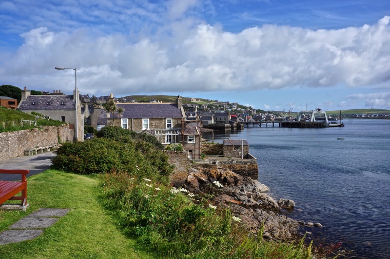
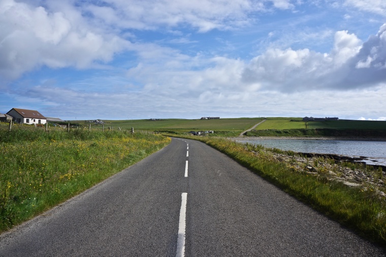
My home base while on the islands was Kirkwall’s Youth Hostel on mainland Orkney. Each morning I walked to the bus depot, located next to the information center in the heart of Kirkwall, about a 10 minute walk from my hostel. Next, I would either hop on a bus, or walk to the ferry (just a 5 -10 min walk down the road from the bus station) and then head to the start of the days hike.
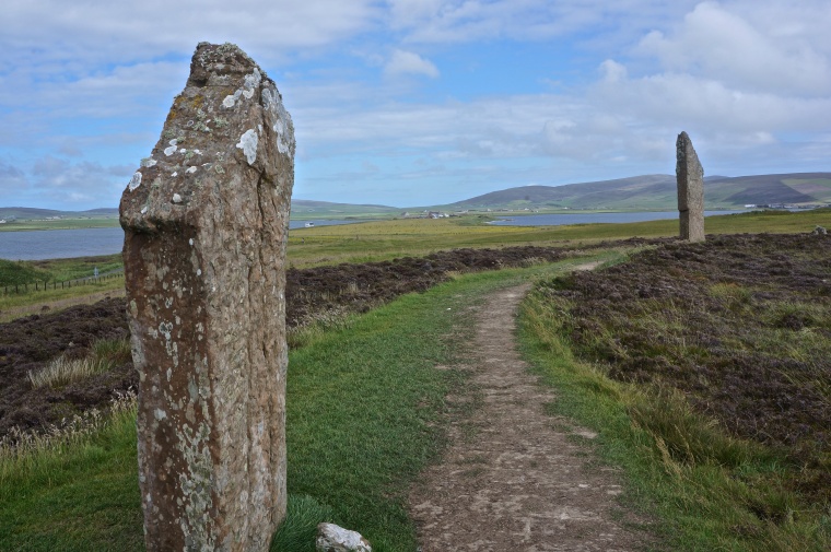
The photos below are from my first day on Mainland Orkney where I took a bus to Skara Brae (shown in later photos), the Ring of Brodgar, the Stones of Stenness, and the Mound of Maeshowe. You could hike from Skara Brae to Maeshowe (about 10 miles). I attempted to do this, but the locals insisted that they give me a ride as there really is no foot path other than the road for cars. Taking rides from the locals was a delight – a great way to get to know them.


The map below shows where the Orkney Isles are located in relation to Scotland, the Shetland Isles and Norway. (source of map unknown)

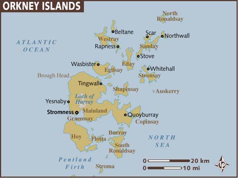
This next map shows the Orkney Isles on a bigger scale, with the names of each Isle. (Map from Lonely Planet)
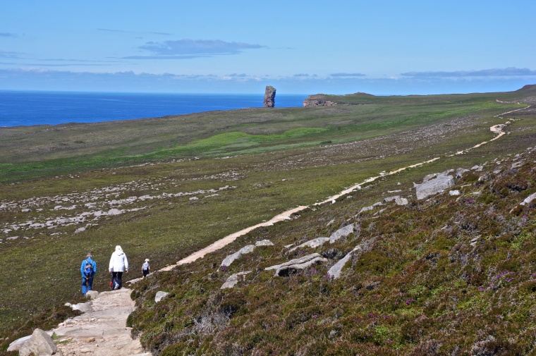
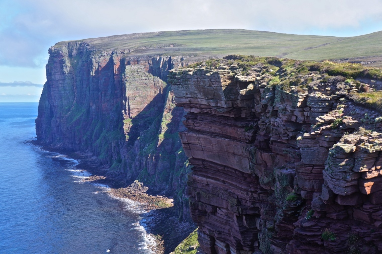
Day Hike #1: Stromness to Yesnaby Cliffs to Bay of Skaill & Skara Brae
(A Coastal Hike to 5000 Year Old Dwellings on Mainland Orkney)
Time: 6-7 hours


Bring layers of clothes for this hike even on a sunny day, as the whipping wind along this coast line can make what was once a warm day change to cooler temperatures very quickly. To stay warm I wore two pairs of pants: workout tights and waterproof pants over them to break the wind, as well as 4 tops. My waterproof jacket and hood (again to break the wind) and my baseball cap underneath to protect my eyes and skin. Due to the whipping wind and intermittent sun, my eyes were killing me by the end of the day. My advice – wear sunglasses! Unfortunately mine broke the day before 😦 And don’t forget your sunscreen!
Day Hike #2: Moaness to Rackwick to The Old Man of Hoy (An Inland and Coastal Hike on the Isle of Hoy) Mileage: 10 miles if taking the bus at Rackwick – 15 miles if doing full round trip


The day turned out to be the best weather I would have while on the islands, blue sky, with barely a breeze and almost 60 degrees – close to t-shirt weather! It was beautiful and quite peaceful.
 After a good hour of enjoying the weather and view and chatting with other hikers, I headed back the same way I came. There is a trail that is more direct to get back to the ferry that goes over Cuilags hill, but it involves protective dive bombing Skuas that aim for the head – no thanks! (Skuas are a type of bird that unapologetically protect their young that nest in grassy fields). I’ll take extra miles over frightening and unpleasant experiences any time. And had I taken the short cut, I would have missed out on this adorable family of sheep and the dramatic cliffs behind them.

On the way back to the ferry just prior to re-entering the valley portion of the hike, a car that was almost full of locals pulled over and offered me a ride. To be honest I was hoping a car would come along and offer me a ride, as I was tired and didn’t have a huge desire to repeat a 4.5 mile section from earlier. I gladly hopped in – the pickle in the middle of the back seat was happily me 🙂
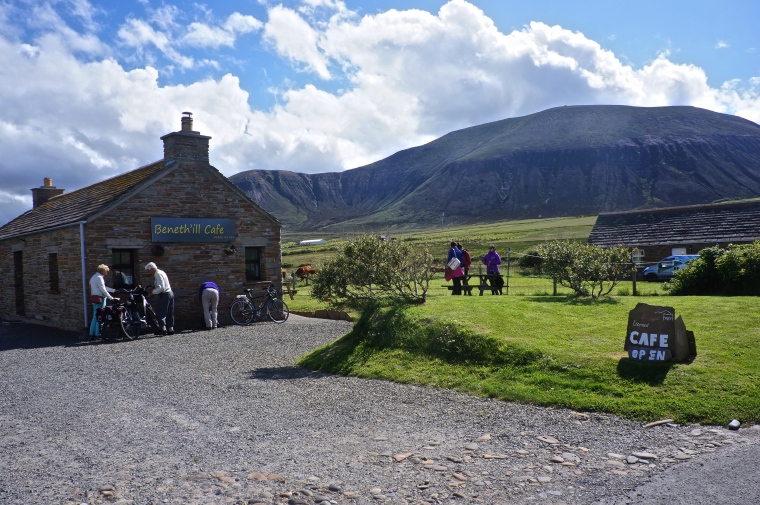
I waited for the the ferry at the ‘Beneth’ill’ Cafe, where stories of the day were shared over tea and toasties. What a great adventure!

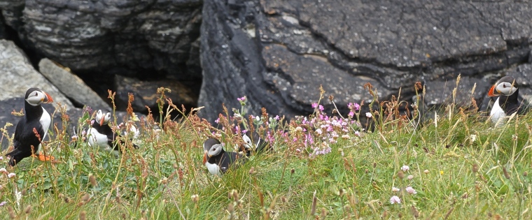
Day Hike #3: Westray Ferry to Puffin Cliffs
(An Inland and Coastal Hike on the Isle of Westray)
Time: Varies as puffin watching can be an enjoyable 30 minute or 3 hour event!
Terrain: Fairly flat
My day started with a walk from my hostel to the Kirkwall ferry. I hopped on the earliest ferry (7:20AM) and headed with locals and bird watchers to Westray Isle and its Puffins! The ferry ride was 1 hour and 25 minutes. I was happy to discover that some refreshments were sold on board. Coffee helped me stay awake for the ride!
Arriving on Westry I discovered that everyone but myself had rides to their destinations. This caused a bit of anxiety when I walked out of the bathroom and not one soul was still there. I was on my own, but was told all I had to do was turn right when I left the ferry terminal and walk the road until I saw a sign that pointed out the trail to the puffins. I was also told it was not a long walk to reach the sign, so off I went. After 25 minutes of walking and two ride offers from the only two vehicles that drove by, I was at the sign. All anxiety disappeared as I turned right and headed up the gravel road that lead to the coastal trail and puffins. I recognized vehicles parked at the start of the trail and ran into a few people that I had met the day before.


Now that you have caught a glimpse of the Orkney Isles, I suggest using this great website: https://www.walkhighlands.co.uk/ to help you prepare further for your adventure in Northern Scotland!
 For more information on trekking in Scotland, come to my February 3rd talk at Savvy Traveler in Edmonds, WA at 10AM.
|
|

thanks for this post. I was up in the Orkneys earlier this year but cycling not walking. One of the highlights for me was Papa Westray , a tiny island with the oldest dwelling in Europe and the Island of Rousay has ancient tombs almost of every corner. Wonderful if the weather is somewhat mixed
LikeLike
Thank you for you comment. I was also on Rousay and walked the roads, I wish I had had a bike 🙂 However getting to many of the ruins may have been tough with a bike. Biking around the Isles would have been fantastic though! I didn’t get to Papa Westray, just Westray. Did you happen to take the shortest scheduled flight in the world while you were there?
LikeLiked by 1 person
No we didn’t fly but did see the plane landing. It was so different to be able to just leave things in safety and not worry about pilfering
LikeLiked by 1 person